
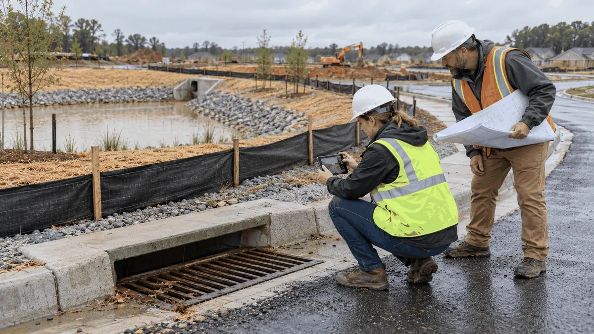
Useful stormwater inspection photos connect a visible condition to its location, date, responsible party, corrective action, and follow-up decision.
Photos are often the fastest way to preserve what an inspector saw, but a camera roll is not an inspection record by itself. A photo without a location, direction, date, or explanation may show silt, ponding, a blocked inlet, or a damaged BMP without showing why it matters or whether the problem was corrected. Municipal programs, developers, contractors, and facility operators get more value when photographs are part of a repeatable inspection log.
The goal is not to create a surveillance archive or collect images for their own sake. The goal is to help a team compare conditions over time, communicate clearly with field crews, prioritize maintenance, and prepare documentation that supports stormwater planning. A practical system can be simple, provided the same information is captured consistently.
Who This Affects
Municipal stormwater inspectors, public works departments, MS4 program managers, construction operators, developers, engineers, environmental compliance managers, facility owners, and HOA or property maintenance teams can use photo logs. The scale differs, but the decision problem is similar: determine what happened, where it happened, who must respond, and how the next inspection will verify the response.
Construction sites may photograph perimeter controls, stabilized entrances, inlet protection, sediment basins, stockpiles, temporary channels, and disturbed areas. Municipal crews may document outfalls, catch basins, culverts, pipes, ditch crossings, and drainage complaints. Industrial facilities may photograph outdoor material storage, housekeeping conditions, drainage paths, and corrective work. Property owners may use photos to explain a recurring drainage concern to an engineer or public agency.
The audience also includes managers who do not visit the site every day. A well-labeled image lets a reviewer understand the condition without guessing. That improves handoffs between inspectors, contractors, maintenance staff, elected officials, and residents, while still requiring a professional judgment about what the image means.
The Stormwater Planning Issue
Runoff conditions are three-dimensional and time-sensitive. A single photo may show a clean inlet while water is moving around it, or show a muddy discharge without revealing the upstream source. A wide context image and a closer detail image usually tell a more complete story. Repeating the same views at each inspection can show whether a control is functioning, degrading, repaired, or no longer needed.
EPA construction inspection guidance emphasizes documentation through forms, photographs, notes, and written logs. That approach is useful because visual evidence supports the narrative, while the narrative explains the visual evidence. A municipality may use the record to track corrective action. A developer may use it to organize contractor follow-up. A facility may use it to evaluate maintenance. None of those uses guarantees permit approval or a regulatory outcome, but each can improve the quality of planning and communication.
Photos can also reduce review delays by making a field condition easier to understand before a meeting. For example, an engineer reviewing a drainage concern can see the inlet, adjacent grade, curb line, and flow path before deciding whether a survey, maintenance visit, or drainage study is needed. A construction manager can see whether an entrance is stabilized and whether sediment is reaching the public road. A public works director can compare a complaint location with asset condition and recent rainfall.
The record must respect privacy and safety. Avoid photographing identifiable people when they are not needed for the inspection, and do not enter a dangerous area just to obtain a better angle. Use safe vantage points, follow traffic controls, and record when an area could not be inspected. A missing photo should not be disguised as a complete inspection.
What to Review Before Moving Forward
Create a photo protocol that fits the program. The protocol should define which assets or BMPs need photographs, how often, what views are required, how files are named or linked to an inspection form, and who reviews the record.
- Capture a context view that identifies the site, access point, drainage direction, and nearby features.
- Capture a detail view of the condition, such as sediment accumulation, erosion, blocked conveyance, damaged fabric, exposed soil, standing water, or discharge evidence.
- Record the location using an asset ID, map point, station, address, or other consistent reference.
- Record the date, approximate time, weather or recent rainfall, inspector, and direction of view when useful.
- Note whether the image shows a deficiency, a functioning control, completed maintenance, or a condition requiring more investigation.
- Link the image to the inspection item, work order, corrective action, or plan-review comment that explains its significance.
- Assign a responsible party and due date when a follow-up is needed, then take a comparable completion photo.
- Preserve the original file or an approved record copy and avoid edits that change the condition shown.
For construction inspections, photograph the BMP before and after a corrective action when possible. A silt fence detail can show a tear, but a context image can show whether runoff is bypassing the entire control. An inlet photo can show sediment, but the inspection note should state whether the inlet was cleaned, replaced, protected, or referred for design review. If the site is in a different phase, note that phase because the appropriate control may change as grading progresses.
For municipal assets, connect photos to an inventory. A catch basin or outfall ID is more useful than a street name alone. Record the asset's condition, observed flow, blockage, structural concern, access problem, and next action. Over time, the photo log can support maintenance planning, drainage complaint triage, capital prioritization, and public meeting explanations.
For industrial or private facilities, photograph the source area as well as the discharge point. Outdoor operations, loading areas, dumpsters, vehicle maintenance, material storage, roof drains, and exposed soil can all affect runoff. A photo protocol should identify what the facility controls directly and what needs engineering, contractor, or agency coordination.
Review the system periodically. Are inspectors taking the required views? Can a reviewer locate the image? Are repeated photos showing progress? Are corrective actions closed with evidence? If not, simplify the form or provide more training rather than collecting more unstructured images.
Set expectations for timing as well as content. A photo taken before a rain event can establish a baseline, while a photo after rain can show flow paths, bypasses, ponding, or sediment movement. The inspection note should state whether the image represents normal dry conditions, active runoff, or post-storm recovery. This context prevents reviewers from comparing unlike conditions and drawing an unsupported conclusion.
Use the same camera position when a condition will be monitored over time. A marked safe observation point, asset ID, and view direction can make a sequence more useful than a collection of changing angles. Where the location is unsafe or inaccessible, record the limitation and explain what alternative evidence was used. Documentation is stronger when it is honest about the boundaries of the inspection.
Planning, Permitting, or Compliance Support That Fits
Stormwater planning support can help a municipality design an inspection and asset documentation workflow that matches its MS4 program, construction oversight process, drainage system, and staffing. Developers and builders may need help organizing preconstruction conditions, SWPPP inspection records, BMP photographs, and plan-review responses so that field information is easier to use during project decisions.
Engineering support may be appropriate when photos reveal a pattern rather than a single maintenance issue. Repeated ponding, channel erosion, undersized conveyance, or outfall instability may require survey, modeling, drainage analysis, or a broader capital plan. A photo log can define the question for that work, but it cannot replace the technical analysis.
Training can help inspectors and contractors understand what to look for, how to describe a condition, and when a photo needs an accompanying measurement or corrective action. It supports compliance planning without promising permit approval, regulatory acceptance, or a particular agency decision. The useful outcome is a record that is consistent enough to guide the next practical step.
Common Mistakes to Avoid
The first mistake is photographing only the problem. Without context, reviewers cannot tell where the image was taken or whether the condition is isolated. The second is using automatic timestamps or file names as the entire record. Metadata can be lost during upload or export, so important identifiers should appear in the inspection form as well.
Another mistake is taking only completion photos. A finished repair matters, but the original condition and the action taken explain why the repair was necessary. A fourth mistake is treating a photo as a measurement. A picture can suggest sediment depth or ponding extent, but a field measurement or survey may be needed for a defensible decision.
Finally, avoid building a process no one can maintain. A two-person team may need a short checklist and a shared folder, while a larger program may need an asset database and work-order integration. Choose a system that preserves the information needed for the decision and can be used on the next inspection.
Next Step
Select one recurring inspection route and test a photo log for a month. Require context, detail, location, date, condition, and follow-up fields, then review whether the record helps the next person decide what to inspect, repair, study, or document.