
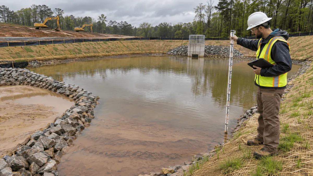
Sediment basin cleanout decisions should be tied to measured accumulation, design capacity, site phasing, and safe access before performance begins to decline. Waiting until a basin looks full can leave a construction team reacting during wet weather, when access is harder and uncontrolled releases are more likely.
A sediment basin is one part of an erosion and sediment control system. Its effectiveness depends on contributing drainage area, stabilization, inlet and outlet condition, storage volume, maintenance, and the way construction changes runoff and sediment delivery. A cleanout plan should connect those moving parts rather than rely on a calendar alone.
Federal, state, tribal, and local construction stormwater requirements differ. EPA's Construction General Permit applies only in areas where EPA is the permitting authority, and other authorities may set different inspection, maintenance, documentation, and cleanout provisions. Teams should review the permit and approved plan that govern the project.
Who This Affects
This issue affects owners, developers, general contractors, SWPPP preparers, qualified inspectors, civil engineers, grading contractors, erosion-control subcontractors, equipment operators, and site superintendents. It also affects municipal reviewers and inspectors who need clear records showing how controls are maintained.
Projects with long grading durations, large exposed areas, highly erodible soils, steep slopes, concentrated flows, or several construction phases can fill a basin faster than expected. Short projects can also experience rapid accumulation after one major storm or a failure upstream.
Responsibility should be assigned before the basin needs work. One person may inspect, another may calculate capacity, a contractor may perform cleanout, and an owner representative may approve disposal. If those handoffs are unclear, a documented defect can remain open while the basin continues to lose storage.
The Stormwater Planning Issue
Sediment basins are designed to detain sediment-laden runoff so particles can settle and flows can leave through a controlled outlet. Accumulated sediment reduces available storage and can change flow paths, short-circuit settling, obstruct the outlet, or raise the chance of overtopping during a storm.
Visual judgment alone is unreliable. Water depth changes with weather and outlet operation, and a smooth water surface can hide an uneven sediment deposit. Sediment may build near the inlet, around baffles, or in a forebay while another area remains deep. A repeatable survey or marked reference gives the team better information than photographs alone.
The cleanout threshold should come from the applicable permit, SWPPP, approved erosion and sediment control plan, design details, and manufacturer's or designer's criteria. Some plans specify sediment depth, percentage of design storage lost, elevation, or maintenance after particular events. The team should not invent a generic threshold when project-specific documents control.
Construction phasing changes the calculation. A basin designed for one drainage area may receive more runoff after a diversion is moved, a slope is opened, or a temporary pipe is connected. Conversely, upstream stabilization may reduce sediment loading. The drainage map and construction sequence should be updated so the basin's required capacity remains clear.
Cleanout itself can create stormwater and safety risks. Excavators can damage liners, embankments, risers, baffles, outlet protection, or underdrains. Wet sediment can be difficult to handle, and haul routes can track material onto streets. Dewatering may require treatment and authorization. Steep or saturated banks, deep water, buried utilities, and soft access routes require careful planning.
Sediment removed from the basin needs an approved destination and controls. Stockpiling it beside the basin can return the material to runoff or add load near an embankment. Characterization or special handling may be needed when the contributing area includes suspected contamination. The project should follow applicable waste, soil, and water requirements.
What to Review Before Moving Forward
Start with the governing documents. Identify the basin's design elevations, storage volumes, contributing drainage area, outlet configuration, emergency spillway, embankment details, cleanout threshold, inspection frequency, dewatering requirements, and restoration notes. Confirm the latest approved revision is in the field.
Establish a measurement method. Options may include surveyed elevations, marked posts, staff gauges, depth checks from fixed safe locations, drone-supported surface mapping where allowed, or calculated volume comparisons. The method should be consistent enough to show change over time and safe for the people collecting data.
Use fixed reference points that will survive construction. Record coordinates, stationing, benchmark information, photographs, and the date. If a marker is moved or buried, note the change and reestablish the baseline. Measurements without a dependable datum can create false confidence.
Review the whole basin, not just the deepest point. Check inlet scour, sediment deltas, forebay accumulation, baffle condition, side slopes, embankment erosion, animal burrows, seepage, outlet blockage, trash, skimmer operation, riser condition, spillway stability, and downstream erosion. A basin may need corrective work even when total sediment volume remains below the cleanout threshold.
Compare current drainage to the plan. Mark active disturbed acreage, stabilized areas, diversions, slope drains, construction entrances, material storage, and any flow that bypasses the basin. A recent phase change may require control adjustments or design review before the next storm.
Review weather and site access. Cleanout should be scheduled when conditions allow safe equipment operation and when the basin can be managed without causing an unauthorized discharge. Consider forecast rainfall, groundwater, inlet flows, drying time, haul-road capacity, traffic, and the availability of a suitable sediment destination.
Define how water will be handled. Pumping, siphoning, draining, or diverting water can release turbidity or erode downstream areas if poorly controlled. The plan should identify authorized methods, treatment controls, discharge location, monitoring or inspection needs, and stop-work triggers. Permit conditions and local requirements should guide the decision.
Protect the structure during work. Establish equipment limits, access points, load restrictions, utility clearance, and no-go zones around risers, pipes, embankments, liners, and spillways. Provide the operator with elevations and components that must remain. If field conditions differ from the design, involve the appropriate designer or responsible professional.
Plan sediment handling before excavation begins. Estimate volume and moisture, select equipment, identify temporary staging only if permitted, stabilize the stockpile, control tracking, and document the final location. Do not place removed sediment where it blocks drainage, overloads a slope, or can wash back into the system.
Set completion criteria. After cleanout, verify the required storage, repair disturbed stabilization, restore baffles or outlet protection, remove tracking, inspect downstream areas, update the maintenance record, and confirm that the basin is ready for the current phase. Closeout should be based on verified conditions rather than the departure of the excavator.
Planning, Permitting, or Compliance Support That Fits
For a straightforward basin with clear details, the SWPPP team may only need a repeatable inspection form, survey reference, threshold calculation, and work-order process. The objective is to connect the observation to a responsible person and a completion record.
Civil engineering support can help when design storage, drainage area, embankment stability, outlet operation, or phase changes are uncertain. Survey support can establish elevations and estimate accumulated volume. Environmental support may be appropriate for dewatering, sediment characterization, or permit questions.
GIS or asset-management tools can link the basin to inspection dates, photographs, measurements, rainfall, work orders, responsible contractors, and disposal records. The tool should support the field process, not make it more complicated. A simple, consistent data model is often more useful than a large form that inspectors avoid.
Permit review should focus on the authority covering the site. EPA's Construction General Permit may be relevant in EPA-administered jurisdictions, while a state, tribe, territory, or local program may control elsewhere. Local grading, erosion-control, dewatering, land-disturbance, floodplain, and waste requirements may also apply.
Good records can support compliance planning, help prepare documentation, clarify responsibilities, and reduce review delays when questions arise. They do not guarantee permit coverage, approval, or a compliance outcome. The responsible parties must still implement and maintain controls under the applicable requirements.
Common Mistakes to Avoid
Do not wait for water to reach the top of the riser before evaluating storage. The critical loss may be hidden beneath the water or concentrated at the inlet. Measure sediment against the plan's threshold.
Do not use the same cleanout depth for every basin without checking the design and permit. Basin geometry, required storage, sediment distribution, outlet type, and governing requirements differ.
Do not measure from unstable banks or enter water to collect a routine reading. Establish safe fixed locations and use methods that match site hazards. Coordinate with the site's safety plan.
Do not pump cloudy water away simply to reach sediment. Dewatering and discharge need an authorized, controlled approach. An urgent maintenance task does not erase permit conditions.
Do not let equipment operators guess where pipes, liners, and embankment limits are. Mark protected components and provide a clear excavation limit. Repair damage promptly and document it.
Do not close the work order after sediment removal without verifying storage, outlet function, stabilization, and disposal. The basin must return to a condition that fits the plan and current construction phase.
Next Step
At the next inspection, compare the basin against its approved detail and maintenance criteria. Establish or verify reference elevations, measure accumulated sediment, review the active drainage area, and open a dated corrective action if the threshold is near or any structural defect is present.
Then build a cleanout readiness sheet that identifies responsibility, survey method, threshold, water-management approach, equipment access, protected components, sediment destination, weather limits, and completion checks. Review it when phasing changes so the team can act before capacity declines.
Sources
United States Environmental Protection Agency, National Menu of Best Management Practices for Stormwater Construction - https://www.epa.gov/npdes/national-menu-best-management-practices-bmps-stormwater-construction
United States Environmental Protection Agency, Construction General Permit Frequent Questions - https://www.epa.gov/npdes/construction-general-permit-cgp-frequent-questions
United States Environmental Protection Agency, 2022 Construction General Permit - https://www.epa.gov/npdes/2022-construction-general-permit-cgp
United States Environmental Protection Agency, Stormwater Maintenance - https://www.epa.gov/npdes/stormwater-maintenance