A consistent culvert condition assessment helps public works teams connect field defects, drainage performance, roadway risk, and capital planning priorities. Cross-drain culverts often sit out of view beneath roads, yet their condition can affect flooding, erosion, sediment transport, pavement stability, maintenance workloads, and access during storms.
Replacing a culvert is more than selecting a new pipe. Teams may need to confirm ownership, limits of public right-of-way, upstream and downstream conditions, utilities, environmental constraints, traffic impacts, hydraulic needs, and connections to the broader drainage system. A field assessment should organize the evidence needed for those later decisions without promising that a particular project, permit, funding request, or design will be approved.
This planning approach can support compliance planning, help prepare documentation, reduce avoidable review delays, and clarify responsibilities. It does not replace permit conditions, engineering analysis, survey, geotechnical evaluation, environmental review, or site-specific design.
Who This Affects
This issue affects public works departments, transportation agencies, stormwater utilities, drainage districts, municipal engineers, GIS teams, inspectors, maintenance crews, emergency managers, and capital improvement planners. It also affects consultants and contractors who support inventory, inspection, survey, design, permitting, and construction.
Municipal separate storm sewer system programs may have good-housekeeping, infrastructure maintenance, mapping, inspection, recordkeeping, and reporting responsibilities that touch culvert work. The exact requirements vary by permit and jurisdiction, so teams should use the applicable MS4 permit and local procedures rather than assuming that one inspection frequency or maintenance threshold applies everywhere.
Roadway staff may first see pavement settlement, shoulder erosion, recurring debris, or a sinkhole near a crossing. Drainage staff may receive flooding complaints or observe sediment at the inlet. GIS staff may discover that the culvert has no asset identifier or that mapped endpoints do not match field conditions. Capital planners may know the crossing needs work but lack enough information to compare it with other projects.
A shared assessment format helps these groups exchange useful information. It should capture both the physical condition of the culvert and the context in which it operates, while preserving a clear distinction between field observations and engineering conclusions.
The Stormwater Planning Issue
Culverts can deteriorate through corrosion, abrasion, joint separation, cracking, deformation, undermining, settlement, and loss of surrounding material. Inlets and outlets can become obstructed by sediment, vegetation, woody debris, dumped material, or damaged end treatments. Erosion can expose pipe ends, create headcuts, destabilize slopes, or affect the roadway embankment.
The same visible symptom can have different causes. Ponding at an inlet may reflect debris, inadequate slope, downstream tailwater, a damaged barrel, an undersized crossing, or a blocked downstream channel. A rusty invert may be a maintenance concern in one location and part of a more urgent structural problem in another. Field staff should document what they observe without assigning a cause that has not been evaluated.
Condition and hydraulic performance should be treated as related but separate questions. A culvert can appear structurally serviceable yet have inadequate capacity for current watershed conditions. Another may carry routine flows while showing significant material loss or joint movement. Replacement planning should not rely on a single overall score without preserving the observations behind that score.
Network context matters as well. One crossing may be part of a series of culverts, ditches, inlets, and outfalls. Raising capacity at one location can move a bottleneck downstream or change upstream storage. A project that focuses only on the barrel may miss channel erosion, driveway connections, side drains, or other assets that influence performance.
Public works teams also need defensible prioritization. Complaints can identify important problems, but complaint volume alone can favor visible or heavily traveled areas. A consistent assessment can bring together condition, consequences, maintenance history, service importance, and known environmental or permitting constraints.
What to Review Before Moving Forward
Confirm the asset identity and location
Assign or verify a unique asset identifier before collecting detailed data. Record the road name, route or segment, coordinates, inlet and outlet locations, crossing orientation, ownership, and available right-of-way information. Note whether the asset is a public cross-drain, private driveway culvert, shared facility, or an unresolved ownership case.
Map both ends when they can be safely located. A single point at the road centerline is useful for general inventory but may not support field navigation or maintenance planning. Inlet and outlet points can help teams compare elevations, trace flow paths, link photos, and identify upstream or downstream assets.
Describe the culvert and end treatments
Record material, shape, barrel count, approximate dimensions, visible length, end treatment, and any lining or repair. Note headwalls, wingwalls, aprons, riprap, safety grates, flared end sections, and outlet protection. If a dimension cannot be measured safely, mark it as estimated or pending rather than filling the field with an unsupported value.
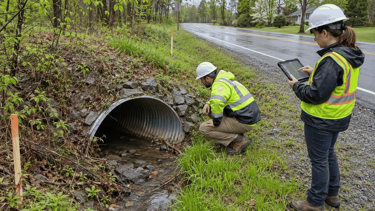
Photographs should show the inlet, outlet, roadway above the crossing, channel approaches, end treatments, and representative barrel conditions. Include a scale when useful and safe. Photo names or attachments should connect to the asset identifier, inspection date, and viewing direction.
Separate condition observations by component
A component-based inspection is more informative than one general comment. For the barrel, document corrosion, abrasion, cracking, spalling, deformation, holes, open joints, separated sections, exposed reinforcement, lining defects, or sediment deposits. For the inlet and outlet, document scour, undermining, displaced stone, damaged concrete, blocked openings, slope instability, and erosion.
Check the roadway and embankment for settlement, cracking, depressions, shoulder loss, guardrail movement, or evidence of soil migration. Record the extent and location of defects. If a condition presents an immediate safety concern, follow the agency's escalation and traffic-control procedures rather than waiting for the normal capital-planning cycle.
Record drainage and maintenance context
Document water level, flow condition, sediment depth where observable, debris type, vegetation, high-water evidence, upstream ponding, downstream tailwater, and erosion. Note recent rainfall because it affects how observations should be interpreted. A dry inspection may reveal barrel defects, while a wet-weather observation may better show restrictions or bypass flow.
Link prior work orders, cleaning dates, complaint records, emergency responses, and recurring blockage reports. Repeated cleanouts may indicate a source of debris or sediment upstream, an access problem, a geometry issue, or a need for a different maintenance strategy. The record should distinguish routine maintenance needs from defects that may require engineering evaluation.
Check the surrounding system
Review nearby inlets, ditches, driveway pipes, outfalls, channels, detention facilities, and other crossings. Confirm where water is expected to come from and where it goes. GIS layers, drainage maps, aerial imagery, complaint locations, and field observations can be compared to identify missing or inconsistent connections.
Identify known utilities near the crossing and note where utility verification is still needed. Record buildings, driveways, sidewalks, trails, trees, guardrails, retaining walls, and other features that could affect access or construction. These constraints can influence survey limits, traffic control, easement needs, and project cost.
Identify review and permitting questions
Before advancing a replacement concept, list the approvals and technical reviews that may apply. Depending on the site, these can involve roadway authorities, floodplain administration, water resources agencies, wetlands or stream review, utility owners, railroads, property owners, or other entities. The list should be treated as an early coordination aid, not a determination that approval will be granted.
Check the applicable MS4 permit, stormwater management plan, maintenance procedures, and recordkeeping rules. Replacement activity may also need erosion and sediment controls, construction stormwater coverage, dewatering planning, spill prevention, and stabilization measures. Responsibilities should be assigned early so required documents are not left until bidding or construction.
Planning, Permitting, or Compliance Support That Fits
An inventory and condition-assessment program fits communities that do not yet have consistent culvert records. The program can define required fields, rating language, photo standards, inspection routes, quality checks, and data ownership. Pilot inspections on several culvert types can reveal whether the form works before it is used across the entire system.
GIS support can connect inlet and outlet points, inspection records, work orders, complaints, road classifications, watersheds, flood-prone locations, and capital projects. The goal is not to produce a map for its own sake. The data model should help users answer operational questions, such as which crossings have severe barrel defects, recurring blockages, missing dimensions, or no recent inspection.
Engineering screening fits assets that show structural distress, recurring flooding, embankment movement, or uncertain hydraulic performance. Screening can define the survey, hydrologic and hydraulic analysis, geotechnical review, structural evaluation, alternatives analysis, and environmental coordination needed for the next phase. It should clearly identify assumptions and information gaps.
Capital planning support can develop a transparent ranking method. Factors may include condition, roadway consequence, emergency access, flood history, maintenance burden, service area, environmental sensitivity, coordination opportunities, and project readiness. Weighting should reflect local goals and should be reviewed for unintended bias.
Permitting support can begin with a constraints matrix that lists potential jurisdictions, submittals, seasonal restrictions, field studies, and responsible parties. Early coordination can reduce review delays when it clarifies what information is expected, but it cannot guarantee a schedule or approval. Project teams should track agency responses and update the matrix as the concept changes.
Compliance support can connect field work to the MS4 program, applicable construction stormwater requirements, pollution-prevention procedures, and documentation practices. This may include inspection forms, maintenance logs, material-disposal records, stabilization checks, and staff responsibilities. The applicable permit and local procedures should control the final approach.
Common Mistakes to Avoid
One mistake is creating an inventory with no rules for uncertain data. Estimated dimensions, unverified materials, and approximate locations can become indistinguishable from surveyed facts. Use confidence fields, source notes, or status values so future users understand what needs verification.
Another mistake is using one condition score without component details. An overall rating may help sort assets, but it should not hide a failed joint, undermined outlet, or roadway depression. Preserve observations and photos so engineers and maintenance staff can understand why the score was assigned.
Teams may also inspect only from the inlet. The outlet and downstream channel can contain scour, obstruction, erosion, or access constraints that change the project scope. If an end cannot be reached safely, document the limitation and plan a follow-up method rather than assuming it is clear.
Replacing a pipe in kind without reviewing watershed and roadway context is another risk. Changed land cover, upstream connections, downstream constraints, and road-service needs may affect the appropriate alternative. Conversely, a larger pipe should not be assumed to solve flooding without analysis of the connected system.
Some programs prioritize only by complaint count or visible damage. That can miss low-visibility assets with serious consequences. A balanced method should consider condition, likelihood, consequence, maintenance history, network function, and data confidence.
Finally, collecting data without a maintenance and governance plan can leave the inventory outdated. Define who closes inspection findings, who updates replaced assets, how photos are stored, when ratings are reviewed, and how urgent issues move outside the normal planning queue.
Next Step
Select a small group of cross-drain culverts that represents different materials, road types, sizes, and known conditions. Test a component-based field form, photograph standards, asset identifiers, safety procedures, and GIS workflow. Review the results with inspection, maintenance, engineering, stormwater, and capital-planning staff.
Use that pilot to refine rating definitions, escalation triggers, missing-data rules, and project-screening criteria. Then establish a schedule for completing the inventory and reassessing assets based on risk, condition, and local requirements. A well-structured record can help teams move from isolated observations to documented maintenance, engineering review, and capital decisions while keeping approval and compliance claims appropriately limited.
Sources
Federal Highway Administration, Culvert Management System background and condition assessment fields: https://www.fhwa.dot.gov/infrastructure/asstmgmt/tamcs_cms02.cfm
Federal Highway Administration, Culvert Inspection Manual: https://www.fhwa.dot.gov/Engineering/hydraulics/library_arc.cfm?id=57&pub_number=31
U.S. Environmental Protection Agency, NPDES Stormwater Program: https://www.epa.gov/npdes/npdes-stormwater-program
U.S. Environmental Protection Agency, Developing an MS4 Program: https://www.epa.gov/npdes/stormwater-discharges-municipal-sources-developing-ms4-program
U.S. Environmental Protection Agency, MS4 Permit Improvement Guide: https://www.epa.gov/sites/production/files/2015-11/documents/ms4permit_improvement_guide1.pdf